

An interview with Joe Slayton, developer of Fractal Terrains Pro.
Joe Slayton created Fractal Terrains with ProFantasy's in-house design team. Known on the CC2 mail list for his dry and self-effacing humor, he reluctantly agreed to be interviewed by the many-tentacled mass of list members. Their questions, and his answers follow. They should be taken with a pinch of salt.
Q: What is Wilbur and how does it relate to FT?
A: Wilbur is the direct ancestor of Fractal Terrains. I have used it as a testbed for many years
to try out various image processing algorithms. Yes, even though Wilbur appears to be and is billed as
a terrain manipulation program, it is actually just an image processing program for monochrome
floating-point images. Not counting all of those terrain-related input and output routines, of course.
Q: Why did you start developing the program?
A: I started developing FT in response to a request from ProFantasy. I had placed a simple FCW
exporter in Wilbur and they thought that it would be a good fit with their product line. They really
wanted a simple and easy-to use terrain generator but the engineers got out of ontrol, with all that
implies.
Q: When you started this project back in the days prior to even Wilbur, did you ever imagine it
becoming what it is today as FT?
A: Wilbur came first, but FT embodies many of the things I had in mind for Wilbur. It also has some
features that went far beyond what I intended for Wilbur such as the on-the-fly computation and dynamic
map projections.
Q: What reasonable feature or types of features that people have requested do you think will
never come to realization?
A: My idea of reasonable is quite different from that of many people, I'm afraid. I have implemented
or am scheduled to implement all of the reasonable features that people have requested. The most
difficult types of features involve trying to force computation-heavy simulations into reasonable
time frames. Climate and erosion simulations are the biggest examples of this sort of feature.
Q: Why?
A: This is where the user's different ideas of reasonable come into play. A five second delay is
intolerable for some people, while others will happily wait two days or longer for a computation.
Climate sims can take days to run on supercomputers with huge amounts of memory. Trying to get decent
results on a mainstream PC is difficult at best.
Q: Did you imagine the program being used in the methods and ways it has been used?
A: As far as I can tell, most people are using FT as a terrain generator to output information to
CC2. That is its intended function, so I suppose I can stretch my imagination that far.
Q: Are you ever impressed by the Output that some users have achieved with FT?
A: All of the FT maps that I have seen so far have a peculiar feel to them that jumps out at me.
It's probably just that my eye is immediately drawn to the strangenesses that FT generates that
makes them obvious. I'll be most impressed when I see maps that I can't immediately tell were
generated by FT.
Q: Any specifics?
A: I think it's the presets with FT. Most programs have a group of presets that make their
output immediately obvious to folks with a lot of experience with the product. I wrote FT so I
likely tend to see the sameness of the output rather than the uniqueness of each user's maps.
Q: Why are rivers so hard to implement?
A: Rivers are actually fairly easy to implement given sufficient processing time and storage space.
The problem with rivers and FT is that a) FT stores worlds created from random fractal functions at
arbitrary internal resolution, b) local topography greatly affects river direction, c) rivers are
part of a large climate and erosion process, and d) FT must generate vector information for rivers.
Trying to cut this very difficult problem down to run on a PC while still getting reasonable results
is the hard part.
Q: What do you see in version FT version 3.0?
A: More of the same, I hope. More fractal functions, a better climate model, better CC2 output.
There are some other features that I would like to implement, but I'm not sure if FT will have a
long enough lifetime to implement them.
Q: Do you use the humorous self-abasing comments to diffuse complaints, or are you really
that hard on yourself?
A: Yes.
Q: What do you do for kicks?
A: I complain to my boss. I get plenty of kicks then, along with the occasional slap. I've been
forced to greatly reduce my habit of freebasing caffeine due to health concerns so I'm trying to
switch over to using mice left-handed as a substitute.
Q: What's your day job?
A: I write data processing and display software for a large company in the United States.
Q: Which feature of FT Pro was the hardest to implement? In what way?
A: Simple create mode was probably the hardest because it required the image overlay system (that's
why image overlays were started in the first place), painting into the image overlay system, a
specialized version of the color-to-altitude tool, and the deterrace algorithm. Lots of little pieces
that all had to work to get anything at all useful out of it.
Getting even halfway decent-looking vector rivers was probably the next hardest, requiring the basin filling algorithm (courtesy Olivier Planchon*, btw), a vector overlay system, and a different vector routing algorithm than the contouring one (FT's rivers don't always flow the same direction along the same apparent basin, making contiguous routing painful).
Q: What combination of techniques in FT Pro do you think results in the most pleasing
combination of realism and aesthetic appeal?
A: As always, best results in FT come from finding a rough world and doing some editing. I'd do
something like this:
- Start with the Wilbur ridged multifractal fractal function because it doesn't have the nasty creasing problem in the original FT fractal functions (an example of optimizing too heavily without paying enough attention to the final output).
- Set an editing resolution of at least 1024 and turn on prescale offsets.
- Use the prescale paint raise and lower tools to adjust mountains and create plains (the roughness tool works properly on land areas that have been modified with the prescale offset tools).
- Expand Land works for making custom tools, but it tends to need a little bit of smoothing after use and doesn't always play nicely with the prescale offset editing. When using expand land, the Continental shelf option should be turned off before use, which eliminates the advantage of prescale offsets.
- Look over the surface and fill in any tiny lakes that will stop rivers.
- Run the basin fill operation on the world after rough editing, then maybe add a tiny bit (0.001) of prescale noise followed by a little bit (0.5ish) of prescale smoothing.
- Run rivers.
The results usually look pretty good if you started with a workable fractal world and are willing to spend a little time with the editing tools.
Q: Do you ever regret the time you have invested in this program?
A: No. Well, maybe a little at tax time.
Q: Do you think the program meets the expectations of most of the users?
A: I'm certain that it far exceeds the expectations of many users but also falls short of the
expectations of many others. On average, it is probably close to what many users expect.
Q: What features are you most surprised by the output? (For good or bad)
A: I can't say that I was really surprised by the output of any of them. I was surprised by one
feature but it didn't make the final cut for FT2 so I suppose it doesn't really count. I don't
particularly like the weather model (it's missing many features of weather models), but it was a
known compromise at the time.
* Planchon, O. and Darboux, F., 2001. A fast, simple and versatile algorithm to fill the depressions of digital elevation models.
"FT has features that a lot of professional desktop mapping/GIS packages would envy. It's robust and produces sheer eye candy. After playing with the demo for a while I finally forked out the dough... well worth it for a product that exceeds all reasonable expectations."
David G
September 6th, 2004
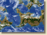
Gaia view with clouds
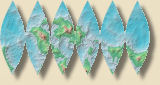
6-way sinusoidal projection
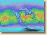
Temperature view
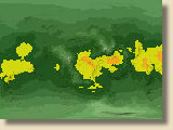
Rainfall view
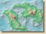
Altitude view