|
|
|
|
Interactive
Atlas®
|
||
|
|
FR Atlas FAQ |
|
|
What is the
Forgotten Realms Interactive Atlas? The FR Atlas consists of three parts. Ø First, over 500 maps of the Realms (800 if you include the update). All of these maps are attractively rendered in full color. Ø Second, the viewer, which enables you to find your maps then print them. Ø Third, the Globe which shows a spherical overview of Abeir-Toril which you can click on to view selected areas in the Viewer. The ViewerWhat can the viewer
do? The viewer is configured to let you navigate quickly and easily between maps and within maps, print the maps at any scale and hide and show features on a map. You can add information to maps and hide and show features. How can I find a
particular map? An indexed search quickly takes you to any related maps; find all overland maps, all maps from a particular product, or all maps containing Waterdeep and Church. You can also select a map using Open, which works just the same way as in any other software. You can use the forward and back button to move through recently viewed maps. Finally, you can select a map from predefined lists of maps called bookmark. An example bookmark lists all the maps in alphabetical order. How can I group
related maps? The bookmark utility lets you select any map from the FR Atlas and add it to a list. You can also add searches to the list. You can save any number of lists. For example, you could have a list of all maps relating to Waterdeep, all maps from a particular product, or a list of the maps you’ll need for your forthcoming session. How quick and easy
is it to search for particular maps? The viewer uses an indexed search; this means that searches happen in a split second. You can search for any text appearing in the body of the map, or in the map notes. The map notes contain product information and map details, so you can quickly find a particular map from a particular supplement. (If you make any changes to the maps, or add maps of your own, you can re-index the FR Atlas. This takes two or three minutes. ) Can I view lists of
related maps? The FR Atlas has a feature called Bookmarking. This allows you to create lists of related maps. You can add to these lists manually, or add a search. You can move bookmarked files up and down the list or remove them. You can make a list of related files for your own campaign, or track the journeys of Marco Volo. The FR Atlas includes some example bookmarks, including an alphabetical list of all maps and a list of Waterdeep related maps. How else can I
navigate between maps? You can select the parent map of any map. For example, if you select the parent icon on the Waterdeep map, you would see an appropriate map of the Sword Coast. You can also get to the parent by clicking on the center of the compass rose. You can click on hotspots to open other maps. For example, if another floor of a building is mapped, you can click on the stairs to open that map; if a town is mapped, you can select it on an overland map and it will open. On overland maps, you can click on the arrows on the compass rose to see adjacent maps, or click on an area to see a focus map. How do I navigate
within maps? You can zoom to any part of the map in at most two steps. You can zoom in, out, to a particular window, to the extents of the map, or to a pre-defined view of the map. Finally, you can find and zoom to a particular item of text; this is particularly useful on large overland maps or cities such as Waterdeep – you can find any street or keyed location very quickly. How can I get
information about the map? How do I hide and
show map features? All of the drawing objects on the maps are divided up into layers. Think of these as overlapping pieces of clear plastic. You can hide a layer (remove the clear plastic sheet) or show it (put the sheet back again). These means that you can hide secret features, traps, keys or text so that players can’t see them. When you print, hidden layers are not shown. What printing
options are there? There are three options that control what you print. First, what view you are printing. This can be the entire drawing, the view you can currently see, or a predefined view. Second, the scale you are printing at. This can be no scale (in other words the view you have chosen fits on the page) or a particular scale (1” = 10’, 1:72, whatever). Finally, you can choose whether to print on one piece of paper, or tile your print across many pieces of paper. A few examples of what you can do: Print the entire map on one piece of paper. Print a particular room of a dungeon at 1” = 10’ Print the entire map of Waterdeep at 1”=50’ across many pieces of paper. Can I export maps? Yes. You can export maps as a high resolution bitmap. Bitmaps are easily converted into other raster-based images such as GIFs and JPEGs. What changes can I
make to maps with the viewer? The viewer is not designed to edit maps, just view them. However, you can add searchable map notes to any map, hide and show layers, or save a particular view, and if you save the map, that information will remain. You can edit the maps, but you’ll need Campaign Cartographer 2 or Campaign Mapper to edit the maps. The MapsHow were the maps
created? We scanned the maps from the source material. Most of the original were black and white and not very detailed. We then recreated each map by drawing over the scan using our Campaign Cartographer 2 software, correcting errors and often adding interesting detail based on the map keys in the source material. Over 100 CC2 users were involved in the project under the watchful supervision of the Forgotten Realms team at Wizards of the Coast. All the maps are in full color and contain as much if not more information than the originals. In addition there are a number of all-new maps including a new level of the Undermountain. How did you create
the overland maps? These were scanned, just as the other maps were, but were much harder to keep consistent; many of the original maps do not fit together properly. We worked from a world-view down, making sure each section fitted with its neighbors. Do maps have square
or hex grids? Most non-overland maps have an appropriately sized and labelled square grid. Overland maps do not have a grid. Non-overland maps that had a hex grid on the original have a hex grid on the FR Atlas version. You can hide or show the grid. What overland maps
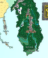
are included? The whole of the Realms has been mapped at overland campaign level, some areas to greater detail than others. The overland maps in the FR Atlas have been consolidated from several sources, with an eye to making the overland map set as complete, up-to-date, and accurate as possible. Where conflicting information appears within the original source material, corrections and changes have been made where necessary through liaison with TSR. What other maps are
included? · All maps from the core FR source products (the "FR" series of reference modules, Volo's guides, "FRS" modules, and the boxed sets FRCampaign Setting, The Horde, Kara Tur, Maztica, Spellbound, The North, Lands of Intrigue, Empires of the Shining Sea, Ruins of Zhentil Keep, Ruins of Myth Drannor, Ruins of Undermountain I & II, City of Raven's Bluff, and the "LC" series of reference modules). · All maps from roughly 95% of the adventure modules published for the Realms from 1986 to 1998. · All maps associated with the city of Waterdeep, including those from FR1 Waterdeep & The North, Volo's Guide to Waterdeep, FRE1 Waterdeep,and the boxed sets City of Splendours and City System. · A good selection of maps from the Arcane Age series (Netheril, How The Mighty Have Fallen, and the Cormanthyr sourcebook). Note that 70% of these maps are included on the release CD of the FR Atlas, the remaining 30% are in the update. A complete list of all maps included in the FR Atlas can be found here. What is common to
all maps? Maps have a compass rose showing north (where appropriate). Maps have a scale bar. All maps have predefined layers; overland, city and floorplan maps have slightly different layer sets. They all look great. What format are the
maps in? The FR Atlas’ maps are stored in a compressed vector format. Instead of using the array of dots found in bitmaps, the FR Atlas stores maps as a collection of geometric shapes that combine to make the map. These are stored in a drawing’s database. Whenever you change the view in the viewing window, the FR Atlas re-calculates what you can see from the database and displays it.. The FR Atlas’ file format has four major advantages over raster-based images (e.g. GIFs and bitmaps). Ø First, you can zoom in and print without any loss of detail. (The PDF files available from the Examples page give you some idea of the final appearance of the maps, although they are limited by the depth you can zoom in – the FR Atlas has no such limitation) Ø Second, the files created are very small in comparison with similarly detailed raster maps. Ø Third, you can hide and show relevant features using layers (for example, printing a player’s map without the secrets on it) Ø Finally, the FR Atlas uses the same file format as AD&D Core Rules Campaign Mapper® and ProFantasy Software’s Campaign Cartographer 2®, so you can use these to edit the maps. The GlobeWhat is the Globe? The globe is a spherical image of Aber-Toril, including never-before-seen lands. It is used when you need to step back and get an overview. You can use the globe to open maps in the viewer. The globe has two images; an attractive relief map and a more prosaic features map. You can swap between the two at any time. How do I control
what I see on the globe? You can use a “hand” cursor to grab the globe and drag it around. You can zoom in to get a more detailed view, or zoom out. How can I select an
area to explore? When you move the arrow cursor over the globe, mapped areas highlight and a yellow tool tip lets you know the name of the area. You can then click on any area to open the appropriate map in the viewing window. What else can I use
the Globe for? You can use it to play the animation that comes with the FR Atlas. Other QuestionsHow can I edit the
maps? If you have Campaign Mapper (in the AD&D Core Rules 2.0) or Campaign Cartographer 2 you will be able to edit the maps in the FR Atlas and create your own. It is much easier to make changes to the maps in the FR Atlas than to start your own from scratch. You will need version 6 or higher of CC2 or CM to edit the maps. The FR Atlas includes a free upgrade to version 6 of Campaign Mapper for existing Core Rules 2 users. How can I add
encounters? If you have Campaign Mapper (in the AD&D Core Rules 2.0) or Campaign Cartographer and Core Rules 2.0 you will be able to link encounters to your map created with Core Rules 2.0. I have CC2 version
5. Can I edit the maps? Yes. Get the latest CC2 upgrade from the Profantasy website. There is a free version 5.99 upgrade, or you can purchase the powerful new version 6 upgrade at $15.00/£10.00 Are there any new
symbols included? We created over 500 new symbols based on original TSR artwork to make the FR Atlas. If you have Campaign Mapper (in the AD&D Core Rules 2.0) or CC2 (from http://www.profantasy.com), the symbols will install automatically and be available for you to add to your own maps. Other questionsWill you be doing Atlases of Greyhawk, Dark
Sun, etc.? It seems
pretty unlikely in the short term. Wizards of the Coast do not think that the
demand is high enough. Will you be doing atlases of other game worlds? This is
much more likely. Watch this space. |
||
|
The Forgotten Realms and the Forgotten Realms logo, AD&D and Core
Rules 2.0 are registered trademarks of Wizards of the Coast, Inc. CC2 and
Campaign Cartographer 2 are trademarks of ProFantasy Software Ltd. This
website is copyright 2001. Contact the webmaster
with any queries. |
|
||