The Cartographer's Annual Vol 8
March ’14
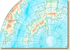
For the March issue we are taking a look at the scientific foundations of map-making. Map projections are the different methods of how to approach the cartographer's paradox: how to depict the spherical surface of earth on a flat piece of paper (or computer screen).
This Annual issue comes with a variety of templates for different map projections, and the accompanying mapping guide discusses what you have to consider when choosing one. We'll also take Fractal Terrains 3 into account and how its map projection feature can be used to leverage even more options for CC3.
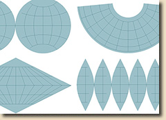
The template pack Map Projections includes
- 24 new pre-defined templates for the CC3 Overland style (imperial and metric)
- 2 new pre-defined templates for the Annual Modern Atlas style (imperial and metric)
- 12 map projection grid parts (grid-only fcw files)
- 1 6-page mapping guide